Arches v 3.0 to be mobile ready, support thesauri, drag-and-drop file upload, more

Arches v 3.0 location-enabled asset inventory and management solution is coming in February 2015 and it will be awesome!
GIS and Big Data Visualization for Asset Management and Beyond

One of the most useful ways to approach big data is to look at it as data that can’t be managed or analyzed by traditional technologies such as simple databases, spreadsheets or KPI dashboards. Geospatial visualization and GIS data mapping are effective alternatives.
Arches Project recognized as one of Planetizen Top 10 Best Planning, Design, Development websites
The Arches Project codeveloped by the Getty Conservation Institute, WMF and Farallon Geographics, was recognized as one of Planetizen Top 10 Best Planning, Design, and Development website
Integrating Big Data search tool Elasticsearch into the Arches geospatial web application
For the Arches geospatial project, to achieve semantically rich data AND high performance, we chose to use Elasticsearch to speed up data access for searches and map display. This post describes how.
Automating Django Testing for GIS Web Applications using LiveReload
When building any GIS web application, regular testing is important. However for some projects, continuous integration testing can be time and cost prohibitive, so developers are forced to manually run test scripts. I describe a solution using Django and LiveReload to automate running test scripts for web applications.
Getting Django to use Postgresql schemas in the Arches geospatial project
How to get Django to recognize Postgresql schemas for the Arches geospatial heritage resources project.
Setting up an Arches Development Environment Using Vagrant – GIS Heritage Resource Management
There are lots of ways in which one could set up an Arches development environment. This post covers one of the simplest approaches that should work across many different OSs.
Arches project has been accepted into Google Summer of Code!
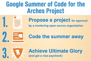
This year Farallon Geographics, the Getty Conservation Institute partnered to apply to Google Summer of Code for the Arches project. We’re excited to announce that we have been approved to be the mentoring organization! We are looking forward to an exciting summer with awesome contributions from students from all around the international community.
Creating Convex Hulls for geospatial data processing and display in OpenLayers Using Quickhull
JavaScript method to calculate a convex hull for geospatial data processing and spatial cluster mapping from an array of OpenLayers features.
eCatch geospatial fisheries management app moves from HTML5 to native iOS to take advantage of GPS

We are developing a new native iOS version of eCatch fisheries management application that will access the iPad’s internal GPS as well as enable connection to an external GPS to improve GPS reception and increase the spatial accuracy of recorded catch locations.
