Today we’re tabling some of our exciting project updates and instead celebrating the initiative and collaboration demonstrated by Peter Hansen, one of Farallon’s Geospatial Systems Consultants.
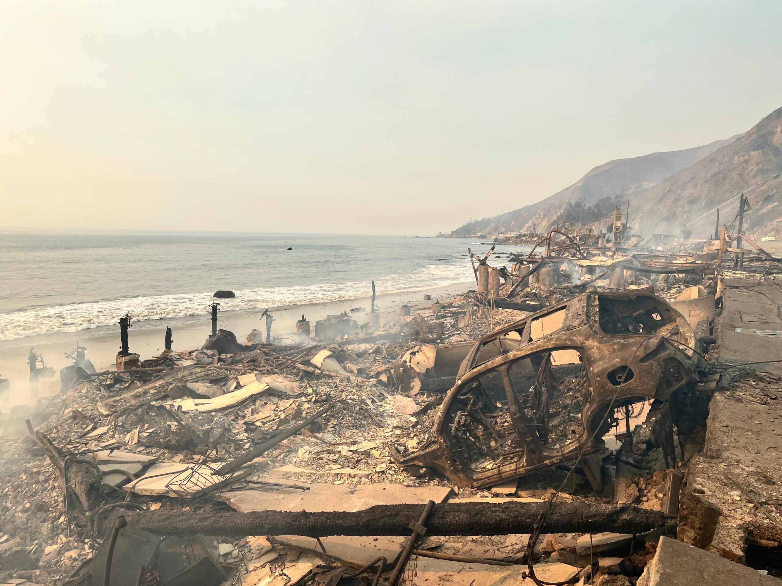
In January, the greater Los Angeles community was rocked by a series of devastating fires which did incalculable damage to homes, neighborhoods, people, and memories. The impact of the destruction was not localized to LA, however; people throughout California, the United States, and the world were affected as they feared for the lives of friends and relatives.
Peter is no stranger to the damage that wildfires can wreak upon the communities that lay in their paths. Hailing from Chico, California, Peter saw firsthand the effects of the extraordinarily dangerous Camp Fire in the fall of 2018 and the lengths that emergency responders had to go through to contain the fire. In the aftermath of the fire, Peter leveraged his GIS experience to help his community work through the trauma of destruction through a critical examination of the effects on the displaced population and what this meant for communal recovery. He also helped author a research article, Displacement after the Camp Fire: Where are the Most Vulnerable?, which further contributed data analysis to this effort.
Unfortunately, Butte County has endured more than its share of fire tragedies. In the summer of 2024, the Park Fire ravaged the area again. And now just six months later, another community was experiencing the same harsh realities.
Combining Data into a Story
Using openly available data published by organizations such as CAL FIRE, NOAA, OpenAerialMap, and Historic Places LA (powered by Arches), Peter compiled information into an web application for local community members to have an accurate geospatial analysis of the fire and the destruction that came along with it. This data, when viewed in isolation, offers valuable insights; but when layered together, it provides a complete picture of the damage—helping decision-makers and emergency responders understand the scope of the disaster, from homes to heritage sites to businesses.
The data analysis didn’t stop at building the Palisades – Eaton Fire Imagery and Damage Viewer. After the fire, Peter worked alongside Altadena Rising to integrate over 25,000 images into their Street View-style map, cataloging the damage to homes and businesses in the affected areas.
We couldn’t be more proud of Peter’s work as a citizen to support emergency response professionals and stewards of the LA community via the Palisades – Eaton Fire Imagery and Damage Viewer. It is our sincere hope that the PAFIDV continues to help in the strategic planning of response and preservation efforts. Peter said it best in his LinkedIn post introducing the tool:
“A big thank you to the teams making this data publicly available and the platforms that enable it—it’s a reminder of how collaboration and technology can help us face challenges like these.”
The power of communities to come together and leverage open data and technology raises the bar for stewardship of the resources that make those communities unique and home to millions. Ensuring that others can benefit from the experience that they’ve cultivated is a core responsibility for stewards and conservationists everywhere.
Supporting Our Fellow Stewards
To that end, we want to highlight the Los Angeles Conservancy and their efforts to grapple with the larger questions of conservation that come after devastating natural disasters. For those of us who haven’t experienced such dramatic changes to our local environments, now is the time to be supportive of our fellows and help reclaim a sense of normalcy.
Peter is speaking at a virtual event hosted by the LA Conservancy this Wednesday, March 12th. People + Places: Altadena: After the Fire and Moving Forward will be a conversation focused on the role of preservation and heritage in supporting Altadena’s recovery efforts after the fire. Registration is free and still available.