Google Maps V3 45 Degree Imagery in OpenLayers

There is a minor ‘gotcha’ in this latest version of the Google Maps API that could cause certain developers a lot of grief which OpenLayers 2.11 will not handle by default. Luckily there is a solution to this issue that is fairly simple to implement.
Software development iterations and data backup for GIS web applications: Part 1
Enterprise GIS web application development is about how to represent your existing data and how to capture new data. Here at Farallon, we have successfully built some very smart geospatial web applications that guide the user in that process. This post is about how we support the backing up of data for these advanced geospatial […]
Dynamic FME Workspaces streamline repetitive tasks and create generic spatial processing tools
Dynamic Workspace in Safe Software FME 2010 allow us to create workspaces that are generic, reusable, and require much less maintenance when compared with using non dynamic solutions.
Section 508 accessibility for geospatial and web mapping applications

Section 508 requirements are particularly challenging for geospatial and web mapping applications. These applications are visual, interactive and dynamic in nature and are difficult to enable for full accessibility.
GIS Web Part’ in the SharePoint vernacular
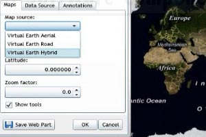
I have been intrigued a new piece of jargon that seems associated with the SharePoint vernacular – “GIS Web Part”
Data drives everything GIS! That’s how an iPhone app helps you avoid parking tickets
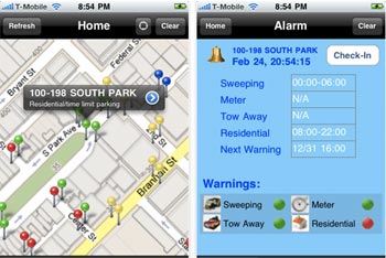
GIS is often confused with cartography, making pretty maps with spatial data. But it goes much further than that. GIS is about spatial DATA, first and foremost, and how spatial features relate to one another. I give an iPhone app as an example.
Efficient processing of source address data into a Master Address Database (MAD) data model
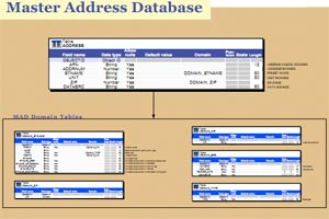
I’m kinda jazzed because I just proved out a script that ingests a series of raw address files and loads them to the Master Address Database (MAD) data model very quickly and efficiently.
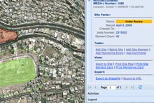
Where’s my stuff? Using Open Source GIS to track archeological treasures in the Middle East

One of the more interesting challenges in building MEGA (Middle Eastern Geodatabase for Antiquities) was thinking through how to make it easy for the archeologists, inspectors, planners, and researchers using the app to find where a specific site or artifact record was in the inventory (from pottery shards to the remnants of ancient cities such as Petra.)
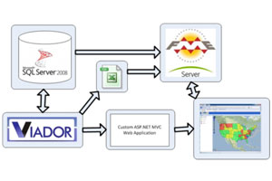
Developing spatial applications with SqlServer 2008, Sharepoint, .NET MVC

I’m sure that most people would agree (well GIS folks for sure) that the arrival of SqlServer 2008 with native spatial types was pretty exciting news. It’s only recently, though, that I’ve really had a chance to see it in action. I’ve just had the opportunity to be involved in a large scale GIS project […]
Liftoff! Just back from the official rollout of Middle Eastern Geodatabase for Antiquities (MEGA)

I’ve just returned from the formal launch of the Middle Eastern Geodatabase for Antiquities in Amman, Jordan. Jordan’s Princess Sumaya gave the keynote address at the launch. Farallon has been working on this project with the Getty Conservation Institute since 2007.
