Designing an Open Source Geospatial Solution to Manage Airport Noise and Operations – Part 1

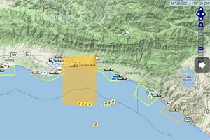
OpenNOMS is a modular and open suite of applications for managing all manner of airport and flight operational information in a geospatial context. The first module of the application suite is FlightTracker, a fully web-based application for monitoring, visualizing, and reporting on airplane flight paths and the noise each airplane generates
Another Great Use of the MarineMap Environmental GIS Decision Support Tool
A former colleague writes to us about his experience with petroleum clients using the MarineMap decision support tool for assessing environmental impact. He writes: “The tools that Farallon helps create are well respected and you never know who might be using it and for what”
The Pitfalls of Assessor Address Data for Cross-Department Address Sharing
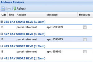
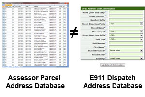
The most common source for address lists in City and County governments is the Assessor’s database. At first glance, this seems to make sense. But scratch the surface and you will quickly see that there are some serious limitations to site addresses sourced from an Assessor database.
Enterprise Address & Maintenance System – Part 3: Why we released as Open Source
In this third post of the three part series, I talk about the advantages of releasing the Enterprise Addressing System (EAS) solution as Open Source. Open Source means you can access it and test it or fully implement it without any licensing costs, before you being customizations.
Enterprise Address Repository & Maintenance Solution – Part 2: Workflows & Application Integration
In this second post of the three part series, I talk about address maintenance workflows and the use of standards in our Enterprise Addressing System (EAS) solution.
Standardize Addressing Across the Enterprise: The Why and How of EAS
Almost everything that a city or county government does or any service they provide is tied to an address. Our motivation for developing the EAS was driven by this fundamental fact and the challenges that local governments have keeping a system up to date and synced across departments
Remodeling GIS Parcel Data for Ease of Use
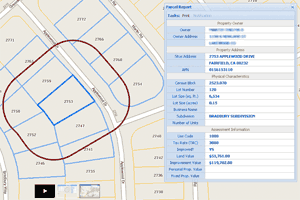
In GIS parcel layers, I find that users tend to assume that APN (assessor parcel number) represents a unique key for each parcel geometry in a County. Nine times out of ten, this assumption is wrong, and results in an inaccurate analysis. The best solution is to create a parcel layer in which APN is a unique key.
If I Were a Small City GIS Manager
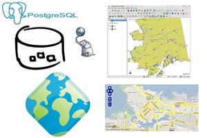
If I were a small city GIS manager, how would I deploy City’s GIS infrastructure? What database? What desktop GIS technology? What application server? What presentation and mapping layer?
Smartphones, tablets, and GPS accuracy….
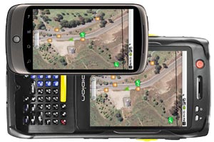
“Can a consumer based smartphone really meet the demands of my organization’s spatial problem? The answer to this really depends on how you intend to apply the spatial data.
eCatch 2.0 – rebuilding sustainable fisheries on the California coast using GIS
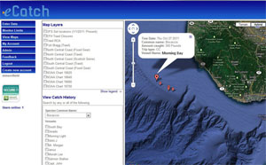
eCatch developed by The Nature Conservancy, gives fishermen real-time information to avoid overfished areas and locate more abundant species. eCatch 2.0 co-developed with Farallon will add a dynamic UI with enhanced mapping and analytic capabilities.
