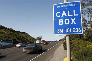
 I wanted to give an update on Farallon work designing, developing and piloting a linear referencing system (LRS) for Caltrans. This is an exciting project as it directly impacts federal dollars received for California highways, as well being an integral component to other statewide mapping and GIS initiatives. Farallon’s role is to develop and prove a process, using the Sacramento area counties as a pilot, that Caltrans can eventually use for a statewide LRS development effort.
A little background on LRS
21st century geospatial data management for transportation networks requires linear reference systems. Linear Referencing is the specification of a location as a distance from a known reference point. An LRS is a set of procedures implemented in software, for determining and retaining a record of specific points along or within a transportation network. Typical methods used are milepoint, milepost, reference point, and link-node.
LRS to Support the Federal Highway Performance Monitoring System
Caltrans decided to undertake this LRS project for several reasons. One is to build and LRS that supports the federal Highway Performance Monitoring System (HPMS) attributes. HPMS is a federally mandated inventory system and planning tool designed to assess the nation’s highway system. At the national level it is used for apportionment, performance measures, highway statistics, and conditions reporting (i.e. funding). On a state level it is used as a management tool to analyze the system’s condition and performance (i.e. funding).
In the absence of LRS, it is not possible to integrate inherently non-geospatial systems such as the HPMS with GIS transportation data without significant GIS data duplication, resulting in increased maintenance overhead and reduced data quality.
LRS for California Road System (CRS) Mapping
Another purpose of the project is to design a coordinated statewide LRS roads layer for Caltrans that can be used for the California Road System (CRS) mapping, geo-coding and event mapping across state and local departments.
What we are doing: Guide, Automate, Implement
The core LRS network represents the “rails” upon which the “train” (dynamically segmented point or line events) depends to get to its destination.
A team from Farallon worked with Caltrans to identify business rules that form the basis of an automated process to calibrate underlying routes and to LRS-enable key business data . Based on those agreed-upon rules, we developed procedures to calibrate the routes based on pre-existing street data. We then converted key business data (such as HPMS segments) to events that can be measured against the routes. And, finally, we provided documentation and training to Caltrans so this process can be repeated on a statewide basis.
If you are really into the nitty gritty, here are some broad descriptions of a few of the tasks we tackled in the implementation phase.
- Defined and created the geometry, routes, standards and measures
- Calibrated measures on the core LRS and HPMS where/if global business rules or tolerances are exceeded
- Created the event table for CRS mapping that dynamically segments onto the LRS


