 The SemanticWeb.com has published The Arches Project Puts A Semantic And Geo-Spatial Spin On Cultural Heritage which describes how the Arches project, a collaboration between the Getty Conservation Institute, World Monuments Fund and Farallon Geographics delivers a semantic geospatial solution for cultural heritage management.
Arches grew out of earlier work to develop MEGA-Jordan, a purpose-built GIS to inventory and manage archaeology sites at a national level for that country. Arches was designed to be more flexible, able to accommodate any country or immovable cultural heritage institution. It was also designed to be more than a GIS and inventory management system.
The Semantic Web for Cultural Heritage
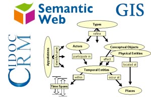
Currently, many archives, libraries, museums, and other cultural heritage institutions make use of the CIDOC Conceptual Reference Model, an information standard that provides a common and extensible semantic framework describing collections and related business entities. The CIDOC CRM defines a common language and conceptual framework for domain experts and implementers. The use of a semantic framework greatly enhances accessibility to cultural heritage information, speeds integration of multiple databases and improves sharing between organizations. Importantly it also works with existing relational databases and aligns with web services.
Arches was designed to integrate the CIDOC CRM. Whereas GIS defines where something is, the CIDOC CRM represents the “who, what and when” in a machine readable form. (Machine readable is key here, because it means that the data definition must provide meaning and context so that a computer can understand the information rather than require a human to interpret it.)
In a semantic data model an entity type might be a heritage artifact, which provides an elementary category that can be easily understood. In a relational model, in contrast, you might end up with a number of different tables such as materials and techniques, designations, descriptions, etc. Each of these things represents part of what makes up the artifact, but with a semantic data model the artifact is the whole entity and its relationships rather than breaking it down into parts.
Integrating GIS with a semantic framework for cultural heritage
By integrating GIS with the semantic framework for cultural heritage,
Arches breaks new ground and enables the system to make connections between cultural heritage objects that might otherwise go unobserved. Since the solution is extensible, it also means the system can continually evolve.
From the SematicWeb.com article:
“We realized early on that to do this right, we weren’t going to be able to do it by defining a bunch of traditional database tables and filling them up with data,” says CEO Dennis Wuthrich. “We needed to think about building an app on the ontology that let people define the kinds of things they wanted to track and the relationships between the attributes of things.” With the help of the English Heritage and the Flanders Heritage Agency, which were familiar with the ontology and had the domain expertise, Farallon developed a graph database that represents the relationship of a site to its name, period, location, actors, activities, architectural heritage, and so on. It’s now building the forms necessary for persons to create and manage that information.
So, if you have a building, for example, there is a semantically defined way of associating a name or set of names with it, and a semantically meaningful way of associating a suite of materials the building might be made up from, its cultural periods, its location and the various ways you can define it (geospatially or relative to its address or an administrative area). “Basically, you have a system that knows how to track these semantic relationships and how to map between something like a physical feature in the field and the data elements defined as the necessary suite of information to manage these cultural artifacts.


